

CONTENTS [click each to view]
INTRODUCTION
Alexis Bhagat & Lize Mogel
MAPS
Unnayan | Chetla Lock Gate, Marginal Land Settlement in Calcutta, 1984
Institute for Applied Autonomy with Site-R | Routes of Least Surveillance
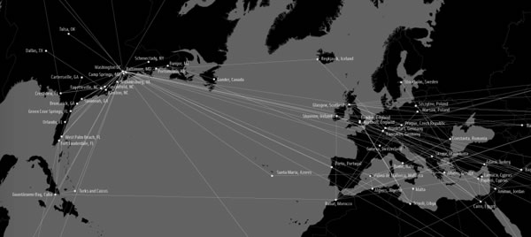
Trevor Paglen & John Emerson | Rendition Flights 2001-2006
An Architektur | Geography of the Fürth Departure Center
Pedro Lasch | Guias de Ruta / Route Guides
Lize Mogel | From South to North
Jane Tsong | the los angeles water cycle: the way it is, not the way it should be and one day will be
the Center for Urban Pedagogy (CUP) | New York City Garbage Machine
Brooke Singer | The US Oil Fix
Ashley Hunt | A World Map: in which we see...
ESSAYS
Jai Sen | Other Worlds, Other Maps: Mapping the Unintended City
Institute for Applied Autonomy | Tactical Cartographies
Visible Collective & Trevor Paglen | Mapping Ghosts
Maribel Casas-Cortes & Sebastian Cobarrubias | Drawing Escape Tunnels Through Borders
Alejandro de Acosta | Latino/a America: A Geophilosophy for Wanders
Sarah Lewison | Our Land is Changing-- Soon Yours Will Be Too
Jenny Price, Jane Tsong, Ellen Sollod, Lize Mogel, DJ Waldie, Paul S. Kibel | Drawing (on) Water in Los Angeles
Heather Rogers | The Power of Garbage
Kolya Abramsky | Struggles Over Transition: Emancipating Energy?
Avery F. Gordon | A World Map
CREDITS
| Mapping Ghosts (excerpt) | Visible Collective & Trevor Paglen Visible Collective: I'm thinking of how you define yourself as an experimental geographer. Cartography is often representative of ideology, and was certainly an accomplice to colonialism. Theories of empire have benefited from warped projections and mapmaking, especially during the European expansion period. Maps are valued for their indexical aspect, yet they are never precise: one example being the arbitrary lines drawn to divide "Hindu" India from "Muslim" Pakistan. The Radcliffe partition lines contributed to ongoing conflict, not just over Kashmir, but also on the Bengal border, Chittagong Hill Tracts, Talpatti, etc. Your projects by contrast use cartography and other research tools to invert the prevailing power structures. Are you using the impreciseness of mapping in any way? In terms of actual use value, the CIA maps were circulated in the public realm as a billboard. How are other users intending to use the information you are making public? Trevor Paglen: I've actually tried to stay away from cartography and "mapping" as much as possible in my work. The "God's eye" view implicit in much cartography is usually not helpful in terms of describing everyday life, nor in describing the qualities of the relationships that cartography depicts. Because of what cartography cannot represent, as you mentioned, it becomes pretty clear why it (and the forms of power that the cartographic viewpoint suggests) have traditionally been such powerful instruments of both colonialism and the contemporary geopolitical ordering of the world (which of course very much comes out of colonialism). My friend Joe Bryan here at U.C. Berkeley has done some exceptional work around questions of cartography in relation to the ongoing struggles of indigenous peoples in the US and Nicaragua. He shows how a colonial/cartographic ordering of the world has forced so many traditional peoples into its imperial logic: a no-win situation that he calls "Map or Be Mapped." I tend to be far more attracted to "on the ground" viewpoints and to embrace their fragmentedness and incompleteness. This project, as well as the "Terminal Air" project with the Institute for Applied Autonomy, are of course notable exceptions. With both of these projects that use the cartographic viewpoint, I was interested in taking what might seem like a familiar image and trying to and make it strange - trying to capture the feeling I had when I first started following CIA flights: it was the constant domestic flights to places like Tulsa, Las Vegas, Fresno, Fort Lauderdale and such that made a big impression on me. In working with John Emerson and the IAA, I insisted that we try to show a continuum between the domestic landscape and the landscape "somewhere else." Neither of these projects are in my view not particularly useful as didactic tools but are instead useful in helping to see the point that we talked about above: that the "darkest" spaces of the war on terror blur into the everyday landscapes here "at home" and are in many way mutually constitutive. In this sense, they're in my view far more similar to Lombardi's work than Ashley Hunt's - they are images rather than analytic tools. Visible Collective: "Ghost" existences -- whether prisons, or prisoners -- is one of the focii of your work. In our work, we looked at another level of disappeared people -- those who slip into the netherworld of immigration violation and racial profiling. Yet, because there are no dramatic icons here -- aeroplanes, CIA, far-away countries, brutal torture, etc -- it is harder to raise mass consciousness on these issues. An interesting challenge for us could be to make the linkages between the areas you explore, and the more prosaic day-to-day disappearances. |